


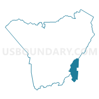
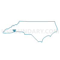
Voting District RR, Henderson County, North Carolina
About
Outline

Summary
| Unique Area Identifier | 640459 |
| Name | Voting District RR |
| County | Henderson County |
| State | North Carolina |
| Area (square miles) | 12.35 |
| Land Area (square miles) | 12.30 |
| Water Area (square miles) | 0.05 |
| % of Land Area | 99.60 |
| % of Water Area | 0.40 |
| Latitude of the Internal Point | 35.23153770 |
| Longtitude of the Internal Point | -82.36965780 |
Maps

Graphs
Select a template below for downloading or customizing gragh for Voting District RR, Henderson County, North Carolina


Neighbors
Neighoring Voting District (by Name) Neighboring Voting District on the Map
- Voting District EF, Henderson County, NC
- Voting District GR, Henderson County, NC
- Jennings Mill Voting District, Greenville County, SC
- Voting District SA04, Polk County, NC
- Voting District SB, Henderson County, NC
- Tigerville Voting District, Greenville County, SC
Top 10 Neighboring County Subdivision (by Population) Neighboring County Subdivision on the Map
- Hendersonville township, Henderson County, NC (47,527)
- Blue Ridge township, Henderson County, NC (11,172)
- Tigerville CCD, Greenville County, SC (8,186)
- Green River township, Henderson County, NC (4,695)
- Saluda township, Polk County, NC (1,972)
Top 10 Neighboring Place (by Population) Neighboring Place on the Map
Top 10 Neighboring Unified School District (by Population) Neighboring Unified School District on the Map
- Greenville County School District, SC (466,178)
- Henderson County Schools, NC (106,740)
- Polk County Schools, NC (20,510)
Top 10 Neighboring State Legislative District Lower Chamber (by Population) Neighboring State Legislative District Lower Chamber on the Map
- State House District 117, NC (85,227)
- State House District 113, NC (75,113)
- State House District 17, SC (37,353)
Top 10 Neighboring State Legislative District Upper Chamber (by Population) Neighboring State Legislative District Upper Chamber on the Map
Top 10 Neighboring 111th Congressional District (by Population) Neighboring 111th Congressional District on the Map
Top 10 Neighboring Census Tract (by Population) Neighboring Census Tract on the Map
- Census Tract 9302, Henderson County, NC (6,797)
- Census Tract 9314, Henderson County, NC (5,476)
- Census Tract 9202, Polk County, NC (5,061)
- Census Tract 40.02, Greenville County, SC (4,959)
- Census Tract 9320, Henderson County, NC (4,542)
- Census Tract 9203.04, Polk County, NC (2,874)
- Census Tract 9203.03, Polk County, NC (1,947)